Backcountry adventure and cuisine for aspiring hiker trash
Five Days in the Winds Pt. 1
Or Two Lowlanders Get A Lesson In Altitude
Last September my hiking buddy Mule and I decided to finally do a bucket list hike. Our first hike together was a thru-hike of the Foothills Trail, and we’d done several AT sections together as well as a couple of local trips. We decided that we felt experienced enough at this point to try something grander.
It was a great idea.
We thought that if we drove straight to Wyoming from Alabama we would get a few hours of acclimitization in towards the end of the drive, which was important since we were going to be at or above 10,000 ft. for much of the hike. My physician suggested premedicating for a few days with gingko as well, but in retrospect that didn’t really help. Neither of us wanted to fool with Diamox because of unpleasant side effects, namely adversely affecting the taste of beer!
So we departed on a Friday afternoon and drove 28 hours straight to Pinedale Wyoming, arriving Saturday evening. Yours truly drove 26 of those hours. The excitement of this trip had me rather hyped. We checked into the Best Western right after arriving.

We took our luggage and gear to our room and then realized that the Wind River Brewing Company was right down the street, and by some strange coincidence we were both hungry and thirsty.

This proved to be a very popular joint, and it was Saturday night after all….so we had to wait a bit for a table. But once seated, we proceeded to crush some of their excellent craft beers, and had a great dinner as well.

Looking back on it, drinking several beers the night before hiking to the highest point you’ve ever been above sea level wasn’t terribly bright.
The next morning we were up early. We made pigs of ourselves at the excellent breakfast in the Best Western lobby and then went outside to meet Kate from GOTCO (Great Outdoors Transportation Company). We left my Expedition in their lot, which was to be shuttled later to the Big Sandy trailhead, from where we were planning to hike out to. Planning, mind you.
Kate drove us up to the Elkhart Park Trailhead, where we discovered that this was a VERY popular hike.


The trailhead by the way is at 9,360 ft. We started out hiking along a gentle uphill grade through some coniferous woods.

t didn’t take long before we were feeling the effects of altitude. Mild headache and light-headedness as well as being slightly short of breath. Nothing too major though.
The Pole Creek Trail eventually opened up briefly into a pretty meadow.

At 4.7 miles we reached Photographer’s Point, where you get the first great views of what you’re getting yourself into.


You can see a smoky haze in the above photos. There were unfortunately some nearby forest fires.
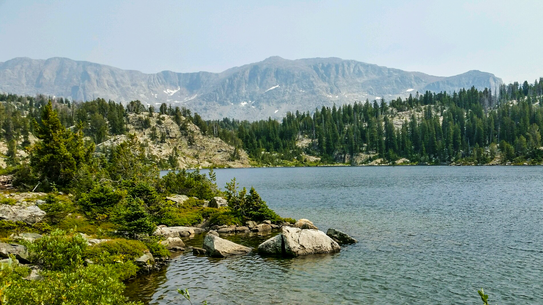
At 5.2 miles we turned left onto the Seneca Lake Trail. At 6.0 miles we passed our first of many beautiful lakes.

To account for possible struggles with altitude (at least I got something right) we had only planned to go 7.3 miles to Hobbs Lake on our first day, but we stopped at a small tarn a bit before that because we were feeling pretty gassed.

We did the usual camp chores and set up our tent. I had purchased a Hilleberg Anjan 3 for this trip, because we were going to be above treeline a lot, and the Wind River Range can have nasty storms at any time of year. I wanted to be prepared for high winds and snow, just in case. Day 1: 6.7 miles.
Our plan the next morning was to hike to Island Lake, pitch our tent, and day-hike into the Titcomb Basin. Sadly, altitude effects kept us from Titcomb Basin. Which at least gives me an excuse to go back one day.
We broke camp and started hiking, passing Hobbs Lake at 10,070 ft. After about a mile and a half, we reached the lower end of Seneca Lake.

Seneca is a pretty long lake, and by the time we got to the upper end, we weren’t feeling very well.

A little ways past Seneca Lake we passed the trail heading left towards Lost Lake, and not long after that we passed the junction to our right with the Highline Trail, to which we would return the next day.

A while later we staggered up to the junction with the Indian Pass Trail that led to Island Lake. The junction was at 10,640 ft. In our pitiful state, the view below gave us hope, as it was downhill for a bit.

On the way down we saw something unexpected- snow.

This had me a little concerned, as we were going to go over a couple of passes at significantly higher elevation than this in the next several days. What awaited us?
We were moving SLOWLY- it was already well into the afternoon- but we finally stumbled our way to our campsite above Island Lake. Despite the haze from the nearby forest fires, we had some great views of what is regarded as one of the most beautiful lakes in the Winds.


I managed to prepare some very tasty penne with vodka sauce that partially revived us, and we made sure we rehydrated ourselves, but we were pretty disappointed at how our bodies “betrayed” us this day. It had totally wrecked our plans. In order to have done our planned day hike into Titcomb Basin it would’ve been another 7.8 miles, and to be honest we didn’t think we could do that even the next day. We sadly came to the conclusion that Titcomb Basin would have to wait for another time, which sucked, because it’s a real highlight of the Winds. But we held out hope that we could otherwise still stick to itinerary. We were deluded. Day 2: a measly 4.9 miles.
It was really, really tough the next morning to eat breakfast and get packed. We were most definitely not feeling it, whatever IT is. Our itinerary called for an 11+ mile day to end up camping at Timico Lake, and we already felt like that was totally out of the question. We decided to just hike as far as we could and play it by ear.
After a little more than a mile we made it back to the junction with the Highline Trail.

It didn’t take long for us to get a view far ahead of Lester Pass. At 11,100 ft. we knew it was going to challenge us.

At least the climb was gentle until the end. As we made our way along the Highline Trail we passed yet another pretty lake. They’re everywhere in the Winds.

However, as we approached the base of Lester Pass we progressively became more winded. And as we started the final ascent, we were DYING. I could only go 20-30 steps at a time before stopping to try to catch my breath…..and the thing was, you couldn’t catch it no matter how long you rested. We both have medical backgrounds, and we were confident that we weren’t entering pulmonary edema territory, so we slogged onward. SLOWLY. I learned later that there was only 55% of the oxygen that we were used to at this elevation. This was probably the single hardest thing I’ve ever done, but the alternative was to turn around and go home. We were hopeful that once we got over the pass and lost elevation, we’d feel better. Ha!
Mule took pity on me and carried my pack the last several hundred yards, but he paid dearly for his act of kindness.

I finally hauled my sorry buns up to the top of the pass as well.

Our troubles weren’t over yet though.
Fivestar,
Do you remember how big the moon was at camp one? I remember that night so vividly that I can smell it.
While ever so softly feeling around for the empty 20oz power aid bottle/foot warmer/tent urinal I noticed what I thought to be twilight. My mind dashed with the thoughts of adventure that lay before us. The last time I felt like this had to be as a child on Christmas morning. Silently unzipping the tent, being mindful of insect trespassers and my sleeping leader I shimmied through the sliver of unzipped Cuban fiber to behold the boldest, brightest, fullest moon that my eyes have ever gazed upon. An involuntary squint slighted my eyes while my hand touched my brow in an effort to dull the glare. I could see. Everything. The grey rocks on the mountain peak, the green grass, the trail etching it’s way past the tarn and through the valley. I could see the trail as it passed over the next saddle. It was as if were twilight or totality during a solar eclipse. Yes, that’s how I described it that night as being comparable to totality. Without a flashlight I made my way up the trail to the top of the saddle then back down around the tarn. As I approached camp I heard Fivestar rustling around. ‘What time you got bro?” I asked. “Three o’clock.” I tried to go back to sleep but every thought of our awaiting adventure sent endorphins coursing wildly through my body. When twilight finally came I got up and finished washing our dishes.
I DO remember! We need to return and finish what we started. I also remember you carrying my pack the final hundred yards up Hat Pass while I flirted with pulmonary edema. Best. Hiking. Partner. Ever.