Backcountry adventure and cuisine for aspiring hiker trash
Zion Traverse Pt. 2
“And out the door I went”
It apparently had dropped just below freezing while we were cowboy camping, but fortunately we’d protected our Sawyer filters, so we were prepared when we reached Wildcat Spring a half mile from camp. Wildcat Spring is one of the more reliable water sources in Zion, but it’s not a gusher by any stretch.

We had to work hard for our water, which was being zealously guarded by a small swarm of angry tracker jackers.

We passed some interesting “rock slides” after we left the spring.

Not long after leaving the spring we caught a glimpse of Wildcat Canyon in the distance.


Although the landscape was the star today, we passed a couple of other interesting subjects for my camera.


2.5 miles into the morning we reached the junction with the West Rim Trail, which we followed for several miles along the Horse Pasture Plateau. Although there were scattered pine trees, most of the plateau had an above-treeline appearance, which made the views seem even more vast.


Periodically we would get more peeks at the canyons that apparently surrounded us.

After (very) roughly 5 miles we began a descent into Potato Hollow, which had a spring. We were about ready to top off our water bottles. “One drink ain’t enough Jack you better make it three.”

After a fairly long but gradual descent, we found the short side trail to the spring. There was a couple camping close by- illegally- and after we cameled up Clinton asked me how likely it was to encounter a ranger, to which I replied “extremely low, but not quite zero.” Well, 2 minutes later a ranger lady appeared out of nowhere and scolded the illegal campers into moving. I had my permit ready, but she didn’t ask to see it.

it was absolutely gushing when we visited.
The lower end of Potato Hollow was a lush flat grassland, and looked like a prime place for a pioneer to settle. I’d bet some trophy mule deer were lurking in the trees, but we didn’t kick any up.
After climbing back out of the hollow- a climb that I thought kinda sucked- we were back on the rim, and back to getting some amazing views.


We had a short but tough climb to reach the junction with the Telephone Canyon Trail. I was starting to struggle at this point, and to Clinton’s credit he was encouraging when I needed it. I probably deserved meows. We then continued a short distance on the West Rim Trail to reach Campsite #6 after what felt like a pretty rough day.

By sheer luck I had selected a campsite that had excellent views and plenty of space. The resident chipmunks and squirrels appeared instantly, anticipating some treats. They were sorely disappointed and scolded us bitterly.


I cooked chicken tagine for dinner (recipe soon come) and it treated Clinton’s innards much more kindly than the previous night’s meal did. And then a little more tequila, and it was dark and we were in our shelters. Day 3: 11.6 miles.
Once again, we were up before daybreak and on the trail by sunrise after choking down some granola and Clif bars. It was right at freezing, so I elected to keep my Kuiu fleece top and bottom on to start the morning. And of course I was too lazy to change out of them later once it warmed up. Since it was our last day on trail, I really didn’t care.
The early sun illuminated more fabulous rock formations and canyons as we hiked the last couple miles of relatively level trail, a prelude to what seemed like 4,000 feet of elevation loss later in the morning.


We almost overdosed on all of the visual awesomeness. However, after several miles we began a long descent on trail that was carved into the side of a sheer rock face that seemed to fall off to our left at least a thousand feet. I wasn’t prepared for this, and clung somewhat fearfully to the side of the trail away from the abyss.


Once we were through playing mountaineer, the trail descended more gradually through a mix of rock slab and trees, with much sandy trail to slow us down. Several miles from the finish line we crossed a nice bridge, after which the trail was largely “paved” with roughly-poured concrete.


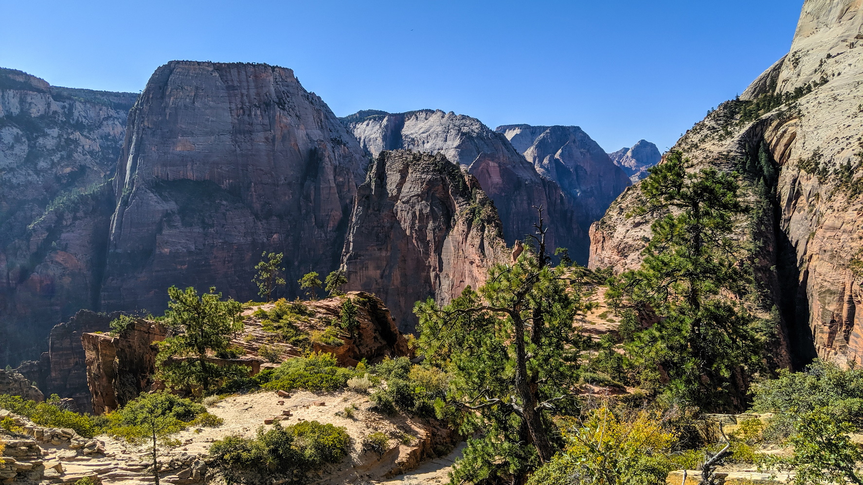
After a short climb up some switchbacks, the trailed opened up on a wide expanse of rock that gave us our first views of Angel’s Landing.


Neither one of us felt good about hiking up Angel’s Landing, especially after we saw the line of day-hiking tourists waiting to do so. It just seemed like nothing good was going to come of that. It’s worth noting that there is a restroom at the waiting area, but we passed by and were soon heading down the 21 steep switchbacks of Walter’s Wiggles that were carved into the cliff face.

I heard at least 20 different languages on the way down.
All I can say is that I’m glad we didn’t start our hike in The Grotto. I can’t imaging doing this descent in reverse. A fair number of day hikers succumbed in their attempt.
At last, we reached the bottom and some flat trail.

From here it was roughly a mile to The Grotto, the last half mile or so losing some more elevation via gentle switchbacks.

The Grotto is Zion Shuttle stop #6, and just as we arrived a shuttle pulled up. A few minutes later we were back at the main Visitor Center. We crossed the bridge that left the park, and hopped aboard one of the Springdale town shuttles. We got off at Stop #3 and headed straight to the Whiptail Grill, which I now regard as a must-do for any visitor to Springdale.

Our waitress Sami recommended the spaghetti squash and goat cheese enchiladas, and they were superb.


After doing our best to satiate our hiker hunger, we waddled over to the parking lot by Zion Adventure and retrieved my car, then drove to our home for the next 3 nights- Zion Canyon Bed and Breakfast. Kinda pricey but so worth it, and heck, it was cheaper than the Hampton.


We ended the traverse portion of our trip here since there was a closure on the East Rim Trail due to rockfall. Nonetheless, we were able to make our final days productive by using one as a town day and the other to dayhike the Zion Narrows.
With a few days post-hike for reflection, I think this was the best backpacking trip I’ve taken yet. Not only did I get challenged, I was blown away by the continuously incredible scenery, AND I was able to successfully introduce a friend to the joys of hiking. Clinton is already texting me wanting to know when the next hike is! I’m pretty sure I’ll remember this trip even when I’m old and demented (I’m not quite there yet). Day 4: 7.9 miles. Trip Total: 41.4 miles.
P.S. If you do this trip, definitely stage out of Springdale, even though it’s expensive. And give yourself at least one extra day to enjoy the food, the beer, the shops and the cool vibe that we seemed to encounter from every person that we met. And I highly recommend using Zion Adventure Company as your shuttle. They’re organized, punctual, and know the region intimately.
Recent Comments