Backcountry adventure and cuisine for aspiring hiker trash
Zion Traverse Pt. 1
“But I’m tired” – George Thorogood
Last week’s trip to Zion National Park was everything I’d hoped it would be.
My normal hiking partner Mule was unable to make this one, but fortunately my good friend Clinton was excited/stupid enough to keep me from hiking solo. Clinton and I have known each other’s e-persona for years on a Tennessee Vols message board, and over the years had met in person several times and decided we actually liked each other IRL too. He had never backpacked before, but enjoys training for half marathons and challenging himself in general. So although a difficult hike such as the Zion Traverse isn’t what you would normally subject a first-time backpacker to, he came through with flying colors.
We both strongly dislike flying, so we made the (in retrospect) dumb decision to drive there from my home in NE Alabama. After enduring said drive, we’re both really interested in Amtrak options for the next faraway trip.
It took us THIRTY hours. We finally took a 90 minute nap break somewhere in New Mexico, only to awaken shivering in the cold. Along the way we drove through northern Alabama and Mississippi on Hwy. 72, nipped Memphis Tennessee where we picked up I-40, crossed Arkansas, Oklahoma and north Texas (hello OKC and Amarillo) as well as northern New Mexico (Albuquerque) and Arizona, crossed the Glen Canyon Dam into Utah, and finally entered Zion from the east on the serpiginous Hwy. 9. After some map confusion which I’m sure had nothing to do with my sleep-deprived condition we found the main Visitor Center. After further confusion inside the center, we finally found the Backcountry Wilderness Desk where a really nice ranger named Hunter Birch issued our online permits and went over spring conditions (excellent) and WAG bag usage with us.
We then drove into Springdale, which lies just south of the park itself. Springdale is now officially my favorite town in America btw.
We checked into the Hampton Inn for Saturday night at a mere $391 and then set out in search of somewhere to fuel up our bodies for the next day’s hike. We found a place called Amigo’s that had some solid Tex-Mex food. And beverages. “But I’m thirsty! (in case you haven’t figured it out by now, Thorogood’s “One Bourbon, One Scotch, One Beer” was the theme song of the week.

the only logical thing- I had both

Unfortunately you had to order food and drinks at the front counter. I ate half of this giant platter while Clinton was trying to order a second beer. The staff then tried to remove his half-eaten dinner while he was in line for a 3rd beer. We decided that we preferred the old-fashioned system with an actual waiter to serve you.
Springdale is situated in a kind of canyon, with lots of beautiful red rock cliffs rising up on either side.

We were pretty wiped out, so we went back to the Hampton to get $391 worth of sleep. We got up at 5AM the next morning and moved our car over to the parking lot adjacent to Zion Adventure Company, our shuttle provider. By 6:30 there were 13 of us crammed into their van. We had to drop off a water cache at the Hop Valley Trailhead, then drop off some hikers at the Wildcat Canyon Trailhead and make a pickup at The Subway before we got onto I-15 and finally took the exit to the Kolob Canyons Visitor Center.

Here we had to show our permits to the ranger on duty, who didn’t give off quite the positive vibe. I got the feeling that she more than occasionally turns people away.

Finally at 9:30 our driver Liesl dropped us off at Lee Pass Trailhead. 6 of us spilled out of the van into a very windy and chilly morning. Clinton and I both immediately donned our rain jackets. Before setting off we got to know the other 4 hikers- Willie, Lisa, Jim and Kevin- who we would leapfrog with for the following 2 days.

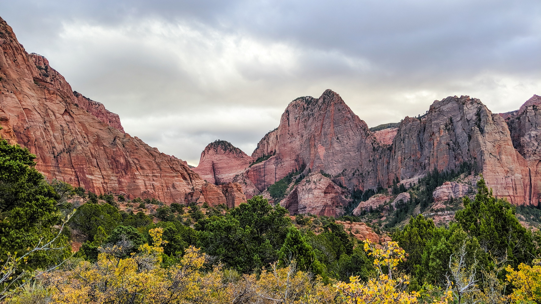
We quickly found the LaVerkin Trail, which generally headed downhill for a couple of miles, passing lots of red rock cliffs and mountains along the way. Even though it was overcast, the colors were pretty impressive.


After about 3 miles the trail leveled off and started to pass through some grassy areas.

The red rocks of the Kolob Canyons continued to amaze us.


As you can see, we were starting to get some fall colors, mostly yellows but occasional reds and oranges. The results when combined with the green conifers and red rocks were spectacular.


We reached LaVerkin Creek at a nice sandy bench that had some trees for shade. We ran into a couple of guys getting water near what looked like a fine swimming hole (on a warmer day).


Although there appeared to be a fair bit of algae growing on the rocks in the creek (which is downstream from cattle activity in Hop Valley), the water itself was crystal clear. And COLD.
For the rest of the afternoon the trail meandered along the creek, often within low growing trees and shrubs, but sometimes popping out from cover enough to give you more views of the rocky cliffs of the canyon.

At 6.4 miles we arrived at the junction with the side trail to Kolob Arch.

Our 4 hiking friends were waiting there at a hitching post for livestock, having already hiked up to it. Clinton and I stashed our packs and did the 1.6 mile roundtrip that involved mild rock scrambling.

From here it was about 0.3 miles to the Hop Valley trail junction. At this point, the trail continuing straight is known as the Willis Creek Trail.

Our itinerary had allowed for the possibility of hiking around 4.5 miles roundtrip from here up to Beartrap Canyon Falls, but we didn’t have enough remaining daylight for that, so we just did another 0.3 miles to Campsite #11, our designated home for the evening.
I had my Slingfin SplitWing tarp and groundsheet set up quickly, despite the windy conditions.

Clinton had borrowed a friend’s TarpTent Scarp 1, and we discovered that this friend had undone all of the loops meant for tent stakes. Given that our combined knot knowledge was about zero, this posed a problem. Eventually we decided that using the optional crossing poles would make setup easier. Clinton also had to reattach the inner tent to the fly. All of this took up about 30 minutes.

While he was getting things right with his shelter, I filtered some water and started to cook dinner. My chicken panang curry was on point.

The fine dust at this campsite stuck to everything, especially shelters. And the windy conditions didn’t help, with gusts up to 30 mph. Our shelters held and protected us well enough though.

After a bit of anejo tequila following dinner, we were in our shelters just after dark. My Ursack Minor thwarted the bold resident mouse we had been warned about. Day 1: 8.5 miles.
“Look man, I’m outdoors you know”
We were up, packed and on the trail by 7:20 the next morning, i.e. daybreak. We knew we had a long day ahead of us. It had only gotten down to the low 40’s by our estimation; we had expected worse.
We backtracked 0.3 miles to the Hop Valley Trail junction.

And then we started climbing. This would be the theme of the day. And there’s nothing my 56 year-old joints enjoy more.

After roughly a mile we descended a short distance into the lower end of Hop Valley.

It was noticeably cooler here. We stumbled close to a half mile through the sand and ran into our friends just as they were leaving the Hop Valley Campsite. We stopped and had a quick snack break.

The morning sun began to illuminate the red rocks of the surrounding canyon.


The trail quickly devolved into a sandy slog. Not only did this slow our pace, it forced us to work harder. Which caused us to grouse more.
Hop Valley is a private inholding that is part of a cattle ranch, and as a result we ran into several gates that we were careful to latch behind us. We wanted the landowner to continue to feel good about allowing us hikers to pass through.

A shallow stream runs through the valley, fed intermittently by smaller springs. Between the water, mud and cattle traffic, the trail sometimes became difficult to follow, and it was almost impossible to keep our feet dry.


Notice the cows in the background.
There were some interesting rock formations as we neared the upper end of the valley.

As we reached the final stretch of this 6.5 mile trail we had a healthy little climb. Some of the trail here was rocky and resembled a washed-out roadbed, which elicited some more grumbling from us. Mainly me. Clinton didn’t seem to be fazed by much. Then again, he’s 18 years younger than I.

The view from the top back down into the valley was a pretty decent reward for our efforts though.

The final stretch towards the Hop Valley Trailhead on Kolob Terrace Rd. was pretty flat but began with more deep sand.


We found a nice break spot with a bench, a memorial to a young man who passed away while hiking in Zion.

The trail then passed through a grassland that looked well-maintained, possibly agrarian even.

6.8 miles into our day we arrived at the trailhead just in time for lunch. Our friends were already there.


Lots of good things happened here. There was a fine restroom facility, so Clinton and I offloaded some cargo. There were also trash cans, so we were able to lower our pack weights as well. And finally, our friends, who had cached 3 gallons of water here, had a gallon left over that they shared with us. Lisa and her husband Willie decided to get off the trail here and were awaiting a pickup from Zion Adventure by the time we took off on the Connector Trail for Wildcat Canyon.
I have hiked on several so-called Connector Trails, and they all appear to have something in common in that they connect two important trails using an unnatural route that is rocky and crappy.
This particular Connector Trail started out innocently enough though.


We took a break from the sun when we finally reached a patch of woods, which is where Jim and Kevin passed us. I get passed a lot.

That big honker nose however got roasted because I forgot sunscreen.
We got back on the trail when we heard Wildcat Canyon calling. It said “Look man, come down here.”
It didn’t take long for this Connector Trail to become a rocky climb like all of its cousins.

Some of the scenery was pretty enough to make one briefly forget the pain of gaining elevation.


4.1 miles after leaving the trailhead, we passed a side trail to the Northgate Peaks trail. We continued ahead through a pine forest that eventually opened up into a long meadow as we approached Russell Gulch. I actually thought that this was one of the prettiest spots of the entire hike.


We re-entered a pine forest and began trying to figure out if we were east of the gulch, which was where dispersed camping was allowed and where we were permitted for that evening. We ended up finding a nice area that appeared to have been used before and surmised that it was legal (it was). We had less than an hour to set up camp and cook dinner before dark, so we decided to save some time by cowboy camping. I cooked up some African Beef Peanut Stew with Pelau Rice that we finished off as the sun set.

I thought that this meal was outstanding, but it turned out that the peanut butter and cashews did volatile things to Clinton’s GI tract the next day.
With this hike a few days in my rear-view mirror, I think it was one of the 5 toughest days I’ve ever had on the trail. The sand and elevation gain made it feel at least 5 miles longer than it was. Which is why before falling asleep I had some more tequila as I thought to myself “Need me a triple shot of that stuff.” Day 2: 13.7 miles.
Read Pt. 2 HERE
Recent Comments