Backcountry adventure and cuisine for aspiring hiker trash
Roan Highlands September 2015
Three years ago my wife (Marmot Girl) and I got away for 5 days and hiked practically in the backyard of where she grew up- The Roan Highlands.
I have deliberately tried to cherry-pick some of the more scenic sections of the AT to share with my wife, for those all too rare occasions when we’re able to weasel baby-sitting duties out of one of our mothers. And without question, Roan Highlands is a top 5 AT section hike for scenery.
We got an early shuttle out from Mountain Harbour B&B/Hostel down to Iron Mountain Gap at TN107. We left our car at Mountain Harbour with a change of clothes, which proved to be an extremely wise decision.

Despite getting an early start, we weren’t planning to crush miles. I had learned on our hike the previous year in Grayson Highlands that Marmot Girl, while very tough, isn’t going to have fun doing 12 mile days. She likes to take a lot of pictures and spend time taking in the sights. On this particular hike, slowing down was a plus, because there was a LOT of scenery to take in.

However, not much of that scenery was during Day 1. We had views of Pinnacle Mountain and Unaka Mountain early on, but spent much of the day in the “Green Tunnel.” About 4 miles in we passed through Greasy Creek Gap, from where you can hike out a short distance to the highly-regarded Greasy Creek Friendly (as opposed to hostile, aka hostel). Cece the proprietor is a thru-hiking legend, and one day I hope to meet her, but that wasn’t in our plans for this particular day.
We hiked a couple more miles and called it a day in mid-afternoon at Clyde Smith Shelter, which we had to ourselves.

Can you guess where the water source for this shelter was? That’s right, you bet your sweet bippy it was 200 yards down a steep hill.
Not only were skeeters out, but I come from a long line of pyromaniacs, and we had nothing better to do anyway, so we built a fire and enjoyed dinner. Day 1: 6.0 miles.


We were well-rested the next morning. Good thing too, because we were going to climb into the high country today.
About a mile into the morning we got our first views of the balds from Little Rock Knob.


My wife got really excited at about this point and seemed to think she had a wonderful husband who thought so much of her that he brought her to this beautiful place.

Unfortunately, what lay ahead was a 2200 ft. climb of Roan Mountain from Hughes Gap, one of the tougher climbs I’ve done in these parts. From Hughes Gap (4000 ft. elevation), we climbed, and we climbed SLOWLY. We finally reached the summit of Beartooth Mountain at nearly 5500 ft., dropped down slightly into Ash Gap, and then climbed again, eventually reaching a zone with spruce and fir trees. It soon became apparent that we weren’t going to make it to Roan High Knob Shelter by dark, and would have to formulate a Plan B. Being a properly-prepared AT hiker means always having a shelter in your pack, and I did indeed have one, so we consulted our notes and decided to shoot for the old Cloudland Hotel site, which is a fairly open area at 6150 ft. about 3/4 miles shy of Roan High Knob, wiith the added bonus of a nearby road access picnic area with real toilets. Nothing makes hikers happier than a place with picnic tables, garbage cans and real TOILETS.
We arrived near dusk, selected a campsite, and pulled out my tent….which I thought was my 2-person Tarptent. Well, it WAS a Tarptent…..but not that one. It was my winter tent, a Scarp 1. And yup, the “1” in its name means it’s a one-person tent.
My poor wife. Not only was she going to have to sleep in close proximity to The Snorlax, neither of us was going to have any room to move. We managed to wedge our 2 sleeping pads and bags into the tent, and of course it then started to drizzle, so we scurried down to the picnic area, where if memory serves me correctly I cooked at least part of our dinner in a bathroom. At this point, I’m not so sure that my wife was impressed with my planning. Day 2: 5.7 miles.

We both slept pretty poorly, my wife more so than me. Luckily, the rain quit, and we had something to look forward to today- the balds!
First we got over Roan Mountain and passed Roan High Knob shelter, which was far enough away that we had to agree that it was a good thing we stopped where we did the previous night.
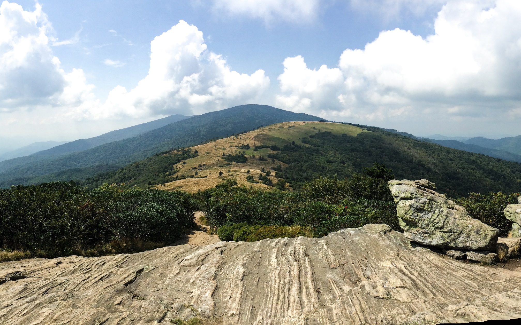
After about 2 1/4 miles we dropped down into Carver Gap at 5500 feet and took advantage of their toilets (much nastier than the ones at Cloudland) before hiking up less than a mile to our first bald- Round Bald.

In rapid succession we then hit Jane Bald and skirted the edge of Grassy Ridge. Three years later, I’m not sure which of these balds are in the specific photos below, but it was all beautiful.


Somewhere in there we had a short stretch with a steep rocky climb, because AT.

About 3 miles later we hit the spur trail to Overmountain Shelter in Yellow Mountain Gap. Not long before that we had a look down into the valley where the shelter is situated.

It was a pretty steep downhill stretch to the shelter, and the return hike the next morning had potential to suck, but it was worth it, because at the bottom this is what we found:

Overmountain Shelter is one of THE iconic shelters on the AT, and if you want to enjoy it you better get there soon, because I learned on my recent section hike at Kincora Hostel that Overmountain now tilts 19 degrees and is structurally unsound, and may be torn down soon.
This shelter has a huge loft and can hold at least 30 hikers, and it has an amazing view down the Roaring Creek Valley.

Although the shelter can sleep 30, on this night there were just 5 of us, including 2 childhood BFF “Cheeseheads” from Wisconsin, and a quasi-homeless guy who was hiking to escape his wife. He claimed that she would show up at trail towns asking him to talk about it with her, and he’d tell her if she wanted to talk to follow him on the trail. Instead, she’d drive ahead to the next trail town and try again. My BS radar was pinging a bit over this story. But he did contribute a nice campfire, and after a dinner of chicken mango curry I shared some libations with our shelter mates. Day 3: 7.5 miles.

We had heard rumors of bad weather coming, so we did our best to get up and out of there early the next morning, which meant that we hiked through morning dew on the way back up to the AT and got the lower halves of our bodies soaked. But the sun came out, and soon we were up on the windy summit of Little Hump drying out. There were occasional groves of stunted trees on the way up that my wife called “fairy forests.” They made great spots to take water and snack breaks out of the sun.
The views at the summit of Little Hump were amazing, but they were only a taste of what was to come.


From Little Hump (5459 ft) we descended down to grassy Bradley Gap at 4960 ft. before beginning the 600 ft. climb to the grass-covered summit of Hump Mountain aka Big Hump, which featured panoramic views of the Doe River Valley to the northwest, Mt. Rogers and Whitetop to the northeast, and Grandfather Mountain to the east. We spent the better part of an hour on top of Hump Mtn. taking pics and gawking at the amazing views.


Eventually I noticed that A) I was starting to get sunburnt, and B) we were almost out of water, so we scurried down the bald for about 3/4 of a mile and entered the woods on a very rocky, slippery trail. It was about this time I recalled the supposed weather forecast for the day and scoffed- yeah, right, rain. Ha. We then ran into a pair of Brits at the weakly-flowing water source. I think one’s name was Derry; one of them was a physician and the other an Anglican priest. They were childhood friends who had decided to do a month-long section hike together on the AT. They appreciated our help in taking advantage of the wimpy water source, and were kind enough to pose for pics.

A little while later we entered something called Doll Flats (I don’t think the name refers to squashed dolls) and all of a sudden we heard a BOOM. Thunder! Zoiks- we still had 3 more miles to go. So of course, it starts absolutely pouring. At least it was a warm rain. As we passed a cliff point and started a 1500 ft. descent, the thunder and lightning came in waves. Honestly it was more than a little bit scary, and we picked up our pace. We passed an unfortunate scene on the way down the mountain. Somebody had chopped down a ton of persimmon trees. Probably one of those infamous persimmon poachers.
Finally after several hours our soggy selves popped out onto US19E, and a quick roadwalk to the left brought us to Mountain Harbor Bed and Breakfast/Hiker Hostel, another one of the legendary stops on the AT. We were greeted by the hostel caretaker Doug “Country Gold” Owens, a former thru-hiker and all-around great guy. We got our room, stripped out of our thoroughly soaked clothes, and each darted into a shower (they had 2). We came out at about the same time and upon returning into our room were overwhelmed by a horrible smell. LOLOL it was our CLOTHES! They reeked! We couldn’t believe that we smelled like that after the rain bath we’d received that afternoon. We bagged those suckers up so we could breathe again.
Several others were staying in the hostel that night, including our British friends. One was to be met by his wife later that evening.
I slipped Doug some coin and asked if he would get a mess of good brews for everyone, and he came back with a case of Fat Tires, which lubricated some excellent story-telling later that night. The one Brit’s wife had arrived to join him for a week of hiking up to the next hostel northbound. Somebody commented, “you do know that that hostel is clothing optional, right?” Typical Brit, she deadpanned “oh, that sounds just lovely.” Day 4: 9.4 miles.
The next morning we partook of the famous Mountain Harbour breakfast, which hostel folks are allowed to have same as B&B folks. I could see why it’s a rare thru-hiker that bypasses this stop. The food was incredible.


After breakfast we took some pics, and chatted with Doug a bit.

Doug was doing work-for-stay for a while until he was ready for his next adventure. We both hated to leave this place, but we missed our kids and was time to get back.
Recent Comments