Backcountry adventure and cuisine for aspiring hiker trash
VA42 to VA624 Pt. 1
So many things go wrong, and it all begins before I even set foot on the trail
Since the beginning of the year, I had had April 6-14 blocked off on my calendar for a section hike, one that was originally intended to be longer. But then life happened.
I am a USA swimming official, and my local club team was hosting it’s annual meet on the 6th. I felt obligated to work it, even though I no longer have kids on the team. And then that afternoon I had to speak at a funeral service for a friend who had unexpectedly passed. And if that wasn’t enough, our family then had to drive to Indiana for my oldest son’s senior college swim banquet (he swims for Ball St.). That was an 8 hour drive split over two days.
The banquet ended at 5 PM. I was detained an extra few minutes by a fellow swim parent who gave me an amazing gift of a case of Three Floyds Zombie Dust. One of the best gifts I’ve ever received.
So, I hit the road at 5:30 for an 8 hour drive to Daleville, Virginia. And somewhere in the mountains of West Virginia, traffic came to a complete standstill for over an hour. I finally stopped at a backwoods Bates Motel for 2 hours of sleep before awaking at 4:30 to finish my drive.
By the time I arrived at Outdoor Trails in Daleville at 7:15 AM, I was a fairly sleep-deprived mess.

I was supposed to have a shuttle driver waiting for me at 7:30.
He didn’t show.
Outdoor Trails didn’t open until 10:00, so I did the only thing I could do. Wait. And think terrible things about my AWOL shuttle driver.
At about 9:45 I wandered back up to the outfitter (still closed) and was soon joined by a hiker named City Slickah (from Boston). He happened to have the number for the shuttle driver at nearby Four Pines Hostel, and he called and hooked me up with Tom. I was profusely grateful- he’d saved my hike- so when Outdoor Trails opened I bought him a pair of gaiters.
Tom arrived around 10:30 with another passenger already in tow, a diabetic with infected blisters. They were searching for an urgent care clinic, but the one in Daleville had a 3 hour wait, so Tom decided to hustle me off to VA42 (Sinking Creek) before continuing the search for a doc.
I was dropped off a little after 12:30 and gave Tom a generous tip for helping me out.
However, this had me 4 hours behind schedule, so I quickly hoofed it across the road and ascended rolling pastures with views of nearby homes.


Shortly after entering the woods, I passed the famous Keffer Oak.

This tree is the second-largest white oak on the AT, with a circumference of 235 inches. It is estimated to be over 300 years old.

The trail began a rocky climb up towards the ridgetop. The stone stepwork was appreciated.


As I reached the ridge (a climb of ultimately over 1,300 ft.) I noticed bad weather rolling in. I tried to quicken my pace, but the trail was often rocky and contorted, which slowed me down. And eventually, the weather caught up to me.
At first it was just a drizzle, but the intensity of the rain quickly picked up. On went the rain jacket and kilt.
Small hail joined the party, and then up ahead looming out of the gloom was a large electrical tower. Naturally, right as I passed nervously under it, the first flash of lightning appeared, followed by booming thunder. More lightning bolts flashed around me. Being on a ridgetop during a lightning storm is a good way to die prematurely, so I bailed down off the trail and huddled under a small rock ledge for 90 minutes like a hobo until the lightning stopped and the rain tapered off.
Now pretty well soaked, cold, and nearly 6 hours behind schedule, I settled for stopping at Sarver Hollow Shelter, 0.3 miles down a side trail. I was the only one there, which was a bit surprising (I was hiking amidst an early thru-hiker bubble). I unpacked, hung up what I could to dry, put on my windpants and Micropuff vest for warmth, changed into dry socks, and kicked back to think about the status of my hike.

I had planned to stay this evening at Niday Shelter, which was 6 miles further down the trail. I ended up reasoning that I could make up those miles over the next 3-4 days without too much trouble. If things broke right.
Satisfied that my section hike was still on track, I went in search of the water source described in Guthook as a “deep pool.”

With nothing better to do, I decided to make dinner, a very tasty meal of Somali Spaghetti. I then checked on my gear (progressing adequately towards dryness) and fell asleep listening to owls around 8:00. Day 1: 4.2 miles.
As is usually typical for me, I was slow to get going the morning of Day 2. I slept in until 7:45, but once awake I took care of water, breakfast and packing fairly quickly and got back to hiking by 8:30. The climb back up the shelter’s side trail wasn’t terrible, and 15 minutes later I was back on the AT.

The trail along the ridge of Sinking Creek Mountain was plenty rocky.

There were several slightly sketchy areas of rock scrambling that were a bit challenging for this middle-aged guy with below-average flexibility.

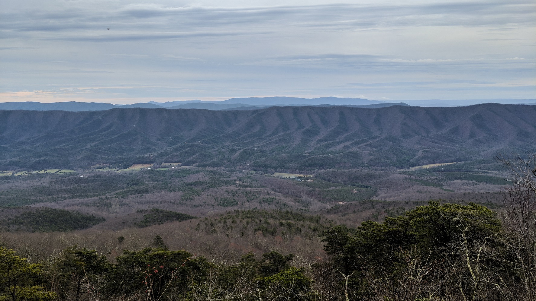
Fortunately, the trail rewarded me with some beautiful views to the southeast after several miles.


At around 4 miles I reached a sign marking the Eastern Continental Divide. When we were kids we used to joke about how you could pee into two oceans at once from such places.

Water sources are scarce on these ridgetops. Here’s the best one I passed by this morning.

At around 12:30 I reached Niday Shelter after hiking about 6.5 miles. It was a perfect time and place for lunch.

I had planned on a quick snack lunch and a short nap, but I was soon joined by a procession of thru-hikers, all of whom were interesting to chat with. First to arrive was Physics, a student at Notre Dame taking the semester off to hike the AT. A few minutes later we were joined by Classic, a late 30’s attorney. Finally, the father-daughter duo of Hummus and Hobbles joined our lunch party. They were in the midst of a 3-week section hike, and it was Hobbles who was the badass hiker who had dragged her dad along for the fun.
Before I knew it, it was 2:00, and my body had decided to begin the process of fossilization while I was laying around talking. It was tough to get moving again.

Thankfully the trail trended downhill from here, and for a while was relatively rock-free.

Further down in elevation, the trail passed through one of the largest Lycopodium patches I’ve ever seen.

It turns out that this particular species is Diphasiastrum digitatum, aka ground cedar, running cedar, or fan clubmoss.
7.7 miles into the day I reached the parking area at VA621, where three battered hikers older than myself were laying on the ground. They warned me that the miles ahead would “ruin a man.”
I crossed the road and pondered my next move, consulting Guthook on my phone. It looked like there was a nice camping area a mile ahead next to a creek, right before beginning the 1,500 foot ascent of Brush Mountain. I didn’t particularly want to make that climb at the end of the day while my body was fading anyway, and I certainly didn’t want to do the water carry required to make a dry camp up there either.
Not far past the road crossing was a footbridge over a small creek.


A random trail sign alerted me to what was ahead.

Next was a large footbridge over Craig Creek.


Based on what I saw nearby, this is a creek that can flood impressively. Not too far after the creek I entered the Brush Mountain Wildnerness.

Trout lilies were everywhere. There was also a random patch of daffodils that suggested an old homesite.

Just as Guthook had noted, I found the campsite right as the trail began to ascend Brush Mountain. I picked out a flat site and pitched my Echo 2 tarp, got water, and futzed around with other camp chores. An older hiker named Jack (yes, that was his trail name, not his real name) wandered in and chatted for a bit before setting up his own camp.

I really like this tarp as my backup shelter on the AT. Including the groundcloth and stakes it weighs under a pound, and it feels like a palace for one person.
I cooked up an extremely savory dinner of Chicken Tikka Masala (recipe to follow in a later post) and had everything eaten and cleaned up in time to turn in at hiker midnight. The woods were unusually silent. Day 2: 8.7 miles.
Recent Comments