Backcountry adventure and cuisine for aspiring hiker trash
VA42 to VA624 Pt. 2
Playing catch up, unsuccessfully
I got a pretty early start the next morning, actually getting on the trail before a thru-hiker (Jack)! I was dreading the roughly 1,500 ft. climb up Brush Mountain, which other hikers had described to me as anything from “a healthy workout” to “the work of Satan.”
Well, the fearmongers were wrong. Imagine that. This was actually one of the better graded climbs I’ve encountered on the AT, with plenty of switchbacks where needed. I only paused briefly several times as the trail contoured over knobs with partial views. Gotta take pictures ya know.


There were quite a few serviceberry trees, aka shadbush, in bloom. They are an old favorite of my parents. Some Amelanchier species are shrubs, but this species was a tree that reaches 20 ft. in height. The berries are supposed to be tasty. They bloom in early spring before most other flowering trees, “when the shad run.”

I kept expecting the trail to eventually degenerate into a rocky mess at some point, but it never did.

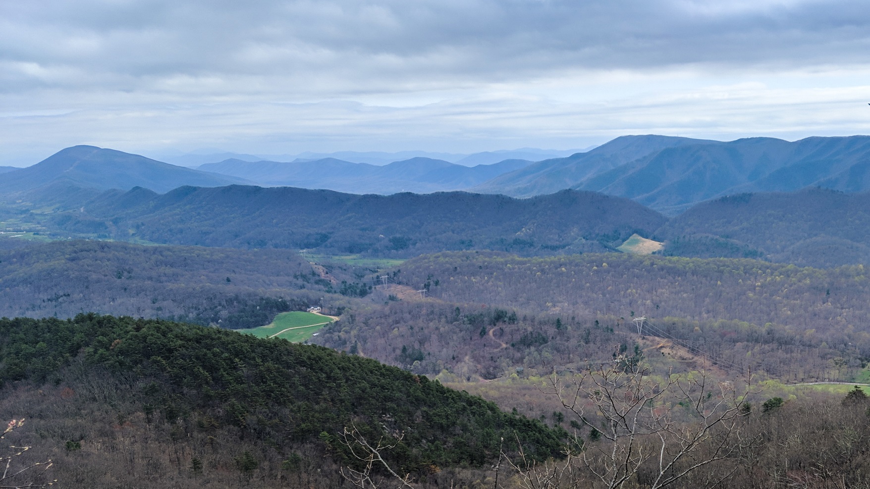
90 minutes after I began, I had finished the 2.1 mile climb and reached the crest of the ridge. A nice surprise awaited me.

Not 5 minutes later, Jack arrived. We chatted a bit but then I took off and left him to have himself a snack as well. The wide, level, grassy trail along the ridge nearly blew my mind.

Obviously the trail was making use of an old forest roadbed, but I sure wasn’t going to complain!
After a little ways I came upon a small pond. This was a water source that wasn’t marked on Guthook, and it may have been ephemeral. It was full of small frogs. Probably newts too.

The trail continued to be glorious, so I made really good time.

I eventually reached the short side trail to the Audie Murphy Monument. I couldn’t pass that up, so I went on up to pay my respects.

Murphy died in a plane crash at or near this site just before his 46th birthday. He was one of the most highly decorated US soldiers in WWII. His military awards included the Medal of Honor, 3 Purple Hearts, 2 Silver Stars, 2 Bronze Stars, and the Distinguished Service Cross, as well as honors bestowed by the French and Belgian military. As a fellow vet I had to salute him before I left. They don’t make guys like him anymore.

It was a sunny day, and I was reminded that hiking on such days before leafout results in sunburn.


Eventually the trail began a long gentle descent. Like my earlier climb, the grade was mild and there were plenty of switchbacks. Periodically the trail would contour over a knob. The trail tended to utilize north-facing slopes, so it was drier, and the vegetation changed. I frequently saw birdsfoot violets.

There were also some more views, this time of the valley to the north of the mountain.


As the elevation continued to drop, things finally got moister, with the appropriate changes in vegetation. I finally found a trout lily in bloom.

Finally after 6.5 miles I reached VA620 at Trout Creek. There was a large cleared camping area there, and Jack had somehow managed to arrive before me.

Jack was actually just leaving, so I took advantage of the solitude to take an hour-long nap. I still hadn’t recovered from my near all-nighter on Sunday. Plus, I’m old enough now to nap whenever I feel like it. Ain’t no shame in my nap game.
I might’ve slept longer, but these big fuzzy black gnats found me and started harrassing me. Every once in a while, one of them would deliver a nice bite too. I flashed back to my small DEET bottle at home with regret. I never seem to learn, bring the @#%$* DEET, every time!
I crossed the road and climbed 50-60 wooden stairs clearly designed to suck whatever rest your muscles had just gotten right out of your body.

The trail quickly reached a small rocky ridge and followed it for a while. Small skinks and fence lizards were scurrying everywhere, but thankfully no snakes. I kept a watchful eye for copperheads and rattlesnakes nonetheless. Especially copperheads. Rattlesnakes at least warn you with a rattle. Copperheads are lazy and sometimes just stay on the trail until you either step over, or onto, them.

1.2 miles after the road crossing I reached the junction with the side trail to Pickle Branch Shelter. It was only about 3:30 in the afternoon, but the next shelter was 14 miles away, and the rugged climb to Dragon’s Tooth lay ahead. This was all dry trail, so if I pushed ahead I was going to have to carry 4-5 liters of water to make dry camp. I was willing to do so, but a quick perusal of Guthook revealed no campsites ahead until after Dragon’s Tooth. Ugh. I was kinda forced to turn right down the 0.3 miles side trail to the shelter.
On the way down I met Jack again, who had gone down to camel up. We chatted for a few minutes, and I learned that he is something of an author. His real name is Rod Riley, he lives out west, and he wrote a Clancy-esque thriller called “Cloud Peak” that has 38 reviews on Amazon, all 5 stars. It sounds like a neat book, and I’m going to order it. In fact, I’m going to do him a solid and link his book HERE.

There were some fields along the side trail that made me wonder if they were old orchards, but they looked too “clean” for that. The subsequent mooing at dusk provided answers.

Shortly after, the trail went up over a hump and dropped down to the shelter.


I was alone upon my arrival, but a half hour later I was joined by a very interesting young lady named Oats, who declared herself fully capable of sharing a shelter with a Snorlax. Obi Wan came by to get water, and then Oats and I were joined by an older guy named OTB (Off The Bench).
I turned out that Oats was almost out of food, and I had a 2-person dinner to cook that night, so we worked out a deal where she went to the water source and filled my Hydrapak in return for some dinner. This particular night’s culinary treat was Youvetsi, a Greek beef stew with orzo and vegetables. It turned out better than I expected, and I had enough to not only feed Oats and myself, but to also share a little with OTB, who was wracked with hiker hunger. They gave it a major two thumbs up.

Oats had a very interesting personal background, and we had a long conversation that lasted until hiker midnight, at which point we were both DONE and fell asleep while listening to cows moo and coyotes yip. Day 3: 8.0 miles.
I got up at 6:30 and studied my options for the next 3 days. I knew that I had to make 33 miles over the next 3 days in order to return to my car by Saturday evening. That’s only 11 miles per day, and normally that’s easily done. But this terrain had been tougher than I’d expected, and I’d only done 8 miles each of the past 2 days. Not only that, but Dragon’s Tooth and it’s difficult climb and descent lay ahead today. The next shelter was 13+ miles ahead, and if I could reach it a pair of ten mile days would get me to my car, so I made that my goal for the day.
It was a good plan. But then the dragon bit me.
I got an early start by my standards (7:45) but decided to carry 5L of water in case I needed to make a dry camp. It wasn’t horrible; I was probably at or just under 30 lbs. even with all that water weight. But it didn’t help.
The 4+ mile ascent to Dragon’s Tooth was a more typical AT climb, with multiple rocky patches and several significant rock scrambles. But it started easy enough with a gentle climb through a young poplar forest.

There were multiple large rock piles that suggested that in the past this may have been a large pasture that had been cleared by a settler.

Eventually the climb got a little steeper, finally cresting at a ledge on a prominent knob.


The first of many rocky patches soon followed. It’s pretty obvious that Virginia is made of rock. Not dirt.

Eventually the trail actually turned to the south and began a more strenuous and rocky ascent.

Occasionally views opened up to the east. They gave me a nice excuse to stop for a picture, water break, and some wind suckage.

As I climbed further I passed a site of importance to thru-hikers.

The rocky climb continued, made even worse by the cloud of large gnats that followed my head despite the cool temperatures and stiff breeze. They would periodically go all kamikaze and dive bomb into one of my eyeballs. Good times.

Less than a half mile from Dragon’s Tooth were multiple ledges with great views.


Suddenly, I reached the 0.1 mile blue-blazed side trail to Dragon’s Tooth itself. Here I met up with a thru-hiker named Ewok. We went down together and arrived at a pretty impressive monolith.

We hung out and took pictures for 5 minutes or so then hustled back up to the trail junction, where I noticed that Ewok was almost out of water. I offered him a liter of mine, which he gratefully accepted and then went off ahead of me while I took a brief blow.
The descent was a rock scramble like I’ve never done before. There were several points where metal handholds had been bolted into the rock, without which I wouldn’t have been able to proceed.


Once the most challenging rock scrambling was over, the trail still did some serious rocky up and down stuff where you had to watch your step. Which is where I failed. My left foot slid between two rocks while my momentum was carrying me forward. Some gymnastics with my trekking poles allowed me to spin and slide my foot free, but not before straining the heck out of my tibialis posterior tendon. Trust me though, it could’ve been a lot worse.

It was hard to tell if this was a significant injury. My ankle was barking, but fully functional. So I kept on going.

I passed a young unprepared-looking couple dayhiking on my way down, just after the trail (for me) niced up a bit. They were about to hit the bad stuff. The young lady innocently asked how the trail was ahead of them. Without thinking, I deadpanned “you’re going to die.” This caused them to nervously confer and ultimately decide to turn around. I felt kinda bad about that. I didn’t really mean to be a fearmonger. Then again, they looked like prime S&R material.
The sign above was at the western edge of a broad flat area in Lost Spectacles Gap, which looked like it had room for a dozen tents. I stopped here to have a snack, then continued on.
Around 2 miles later I found myself at VA624. It was around 2PM and I’d come about 7.5 miles in 6+ hours. Not bad at all for me considering the terrain.

Despite the roadkill, I was hungry. About a third of the mile to the right was Four Pines Hostel, where a lot of thru-hikers had been staying. About the same distance to the left was the famous Catawba Grocery, which had a grill. Which means cheeseburgers.
I chose cheeseburgers and went left. ALWAYS go to where the cheeseburgers are.


This is why I always carry cash. A short while later I was sitting with 3 other thru-hikers including Obi Wan at the picnic tables out front, making quick work of 2 quarts of Gatorade Zero, 2 chili dogs, a cheeseburger and fries. FWIW, Catawba Grocery was very friendly and offered a full set of typical resupply options, including fuel canisters.
While we were feasting, the blue shuttle van from Four Pines pulled up and disgorged a bunch of thru-hikers, including Oats and Ewok, who exclaimed “there’s the guy who saved me” and gave me a big fistbump.
All of a sudden it was 3:00 and I had a decision to make. Could I hike 6 more miles to the next shelter on a barking ankle? I wasn’t sure. And then I overheard the thru-hikers talking about thunderstorms rolling in tomorrow morning; most of them were planning to zero at Four Pines as a result.
This was my last feasible bailout point too. I felt like a lot of things were guiding me towards making the safe call, so I asked the guy driving the van if he could ask Tom to pick me up when he got back. 30 minutes later Tom was loading my pack into his car.
Tom by the way is a GREAT guy. He was once again properly tipped after he dropped me off at the HoJo’s on 220 in Daleville, where I had foolishly made reservations for Saturday night. They were nice enough to move it up to the current Thursday. But I have to tell you, the HoJo’s is a dump. Obviously built in the 60’s and unmaintained since that time. My room had the stale odor of long ago cigarettes and fat sweaty salesmen. I heard every word of the heated argument the couple had in the room next to me. And the “full hot breakfast buffet” was nothing more than do-it-yourself waffles and muffins. No eggs, no meat. I see now why the thru-hikers were all targeting the Super 8. You are hereby forewarned. Day 4: 7.2 miles. Trip Total: 28.1 miles
A cool rainy morning greeted me before my drive home, and my ankle still felt tweaky, so I guess I made a good call. Certainly I wasn’t going to have had good weather when I would’ve hit McAfree Knob. The plan is to return and pick up this hike in June, perhaps in better fitness and hopefully in better weather.
Recent Comments