Backcountry adventure and cuisine for aspiring hiker trash
Max Patch to Hot Springs
A brief and beautiful hike during a severe drought
It seems like it was longer ago, but a mere three years ago this October Mule and I did one of the laziest weeks ever. We started at Sams Gap and hiked 43 miles generally downhill into Hot Springs. And then, because we were lazy, and partly because we enjoyed Hot Springs so much that we wanted to end the hike there, we shuttled down to Max Patch and hiked back, thus avoiding a killer southbound climb leaving Hot Springs. Sue me. This is one of the advantages of section hiking. And I was kinda fat then.
Unfortunately, I’ve lost the photos from the first part of that hike and a few from the second as well. I was carrying an actual camera on this trip, and it wasn’t all that great.
North Carolina, and in fact much of the southeast, was in the midst of a pretty severe drought at the time. We had gorgeous weather as a result, but water was HARD to come by.
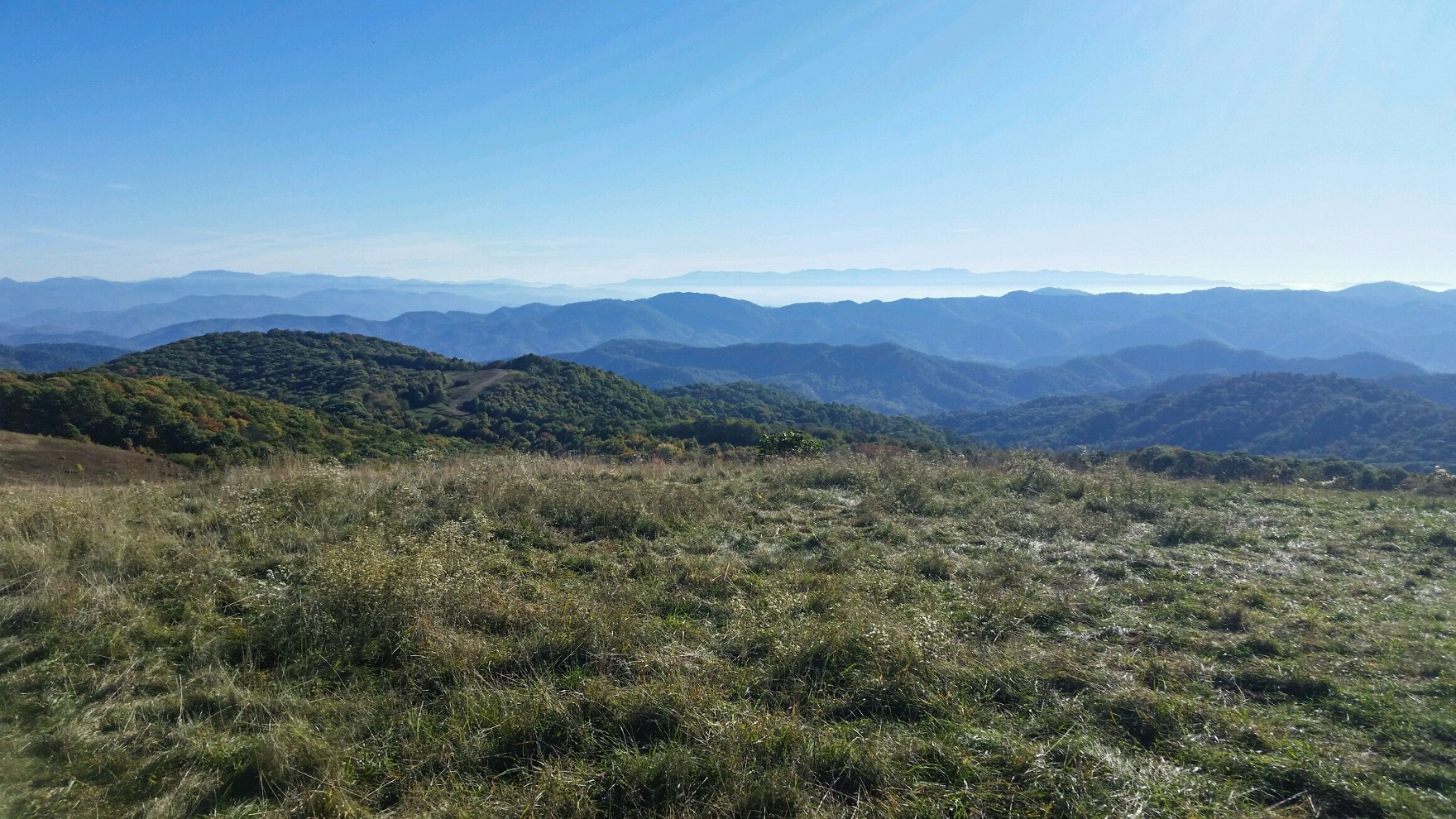
Our driver Mary shuttled us up to Max Patch road on the morning of October 12th, and we made quick work of the 400 ft. ascent to the summit of Max Patch itself. The 360 degree views were utterly amazing. We were half tempted to just pitch our tents there for two days.


There were actually some fire rings and what sorta looked like established campsites, which made it really, really tempting. We hung around for the better part of an hour and took it all in. There were of course a couple dozen other folks milling around, mostly day hikers.
Mule thought it was the coolest place ever.

Eventually we realized we had 8 miles to hike, and it was late morning already, so we headed over the bald and down towards the woods.


As we entered the woods there was a small stream that we probably should’ve taken advantage of.


A little shy of 2 miles into the day we entered an impressive rhododentron “tunnel.”

A short while later we crossed over a grassy field.

Less than a mile later we passed the side trail to Roaring Fork Shelter. By the time we reached Lemon Gap 5.2 miles into our day, our water bottles were empty. The alleged stream before the gap had been dry. And the stream after the gap….dry again. We were banking on the piped spring at Walnut Mountain Shelter.

We reached the shelter at 6.5 miles. The guys who had stopped there ahead of us said that they had been unable to find the spring. It turned out to be on a poorly-marked and overgrown side trail….and it wasn’t flowing. Shizzle. Our notes told us that the next water source was over 4 miles away, and we were thirsty NOW. With nothing else to do, we continued on.
In a stroke of great fortune, we found a seep a mile later that appeared unusable until Mule crafted a “pipeline” out of a series of rhododendron leaves that resulted in a small trickle.

Knowing we were going to have to dry camp that night, we spent a LONG time filling every water reservoir that we had. This proved to be a good call. The so-called brook at Mile 8.2 was indeed dry.
We began the climb up Bluff Mountain but stopped shy of the summit at an established campsite that may have been Phil’s Gap.
I believe this may have been the first night that I pitched my Echo II tarp.

It was getting chilly, so Mule took advantage of a conveniently-placed boulder and used his industrial firefighter skills to crank out a nice fire that reflected heat towards our shelters.

IIRC we had some chicken panang curry and Ballast Point Mango Even Keel for dinner. The beer helped us conserve our water. Day 1: 8.6 miles.
Back in those days I was still fooling around with cooking breakfast. I have since decided that I don’t want to carry that extra food weight, nor do I enjoy spending the extra time to cook when I should be hiking. Not a big fan of having to clean pots in the morning either.
But on this particular morning, I whipped up some berry pancakes and hash browns, and they WERE pretty good as Mule’s expression attests.


After we broke camp we hiked a short distance to the summit of Bluff Mountain (elevation 4439 ft.) and then descended along some switchbacks, crossed a dry streambed and some old woods roads, and eventually came to Garenflo Gap (2500 ft.) at 3.7 miles.

It turns out that it was actually a bit longer to Deer Park Mountain Shelter, which appeared to be empty when we arrived. That is, until the resident mouse scurried out to greet us.
This was an old shelter, built around 1938, and it showed.


We were alone when we arrived, but an hour or so later we were joined by five SOBO thru-hikers who had resupplied earlier in the day in Hot Springs and hauled their now-heavy packs up a 3000 ft. climb to the shelter. They were all bitching about how heavy their packs were. I told them “guys, my pack is heavy too….in fact, I was hoping y’all could help me out with that.” Absolutely not they all said, their packs were already too heavy with food. “Well, MY problem is that I brought too much tequila.”
You have never seen five heads pivot in unison like theirs did, like O RLY?
As it turned out, I cooked up a killer sour cream skillet enchilada dinner with refried beans and spanish rice (as well as queso and pico), and had brought a bunch of Packit Gourmet’s most excellent margarita mix….and some reposado tequila. Enough for seven hikers in fact. Mule and I quickly had five friends for life. After dinner, our new friends built a nice campfire and brought out some herbal supplements iykwim. We stayed up later than usual listening to their thru-hike stories and pretty much laughed our asses off. By the time we turned in, we weren’t worried about mice any more. Day 2: 7.3 miles.
The next morning we got up early, hoping to get breakfast in Hot Springs. The three mile jaunt down the mountain went quickly, and before we knew it we were at the famous Smoky Mountain Diner.

They happily seated our smelly hiker trash selves, and we proceeded to order the better part of their entire breakfast menu. We had platters of food EVERYWHERE. And we ate every darn scrap of it too. We then waddled back to my car and drove home.
I would be remiss if I left out mentioning where we’d had dinner the night before our shuttle. Spring Creek Tavern is another must if you visit Hot Springs.


We ate on the patio and had massive burgers and fries. And a craft beer or three. Highly recommended. Day 3: 3.1 miles. Trip Total: 19.0 miles.
Recent Comments