Backcountry adventure and cuisine for aspiring hiker trash
Catawba To Glasgow Pt. 3
A little bit of yellow-blazing before a strong finish
It had rained steadily all night, but by morning the skies were clearing. I nonetheless had the joy of packing up a wet tent, always a good time. The day’s itinerary looked favorable, with only one halfway significant climb in the afternoon. Although I got a fairly early start, Groucho and Wild Violet were already gone.
There were pockets of low-lying clouds over the valleys.

There was a lot of flat, friendly trail in front of me as I slowly descended 700 ft.

At just under 3 miles I reached the Cove Mountain Shelter, where almost all of the thru-hikers were still in their hammocks, although I did get to meet Blackjack and Meep briefly. I had a quick snack and moved on.

The morning dew outlined a bunch of haphazard spider webs.

At 4.4 miles I arrived at the Buchanan View, which has a view to the west of, you guessed it, the town of Buchanan.

The slightly warm and moist conditions finally brought out some of my favorite critters of the woods.

After descending 1,100 ft. further I caught up to Groucho and Wild Violet at Jennings Creek, where the trail crosses the creek on a single-lane bridge before beginning a climb of Bryant Ridge.
However, Groucho had previously mentioned that there was a nearby campground, and we found one of their flyers posted on the bridge. Middle Creek Campground was only 1.5 miles away, had a grill and a store, and offered free shuttles to hikers. Everyone was in the mood for some grill food, so I called them up, and 15 minutes later we were in a short bus piloted by Crystal the Pistol, on our way to cheeseburger heaven.


We took a load off, and Crystal took our orders and got to cooking. We all ordered cheeseburgers, and a couple of Gatorades too. Wild Violet added a milkshake to her order. And before long we were inhaling calories. Tasty and greasy ones.


However, the afternoon was about to take an unexpected turn. Crystal informed us that a big storm was going to hit in the next hour or two, right as we would be cresting Bryant Ridge. None of us were thrilled about getting rained on again, but I was particularly concerned about repeating the ridgetop thunderstorm adventure of my last section hike. Crystal was trying to talk us into staying at the campground, but I really needed to keep more on schedule than that. I needed to be at Bryant Ridge Shelter tonight, and stopping at Middle Creek would leave me almost 4 miles short of that goal.
At this point, wise old Groucho suggested that we take a blue-blazed trail to the shelter off a nearby road. It was less than a mile long and would get us to the shelter before the storm. BUT, it would mean skipping 3.7 miles of actual AT. This practice is called yellow-blazing, and if I was on a thru-hike, I wouldn’t do it. I would’ve just stayed at Middle Creek. But section hikers have to stay on schedule, so I was game. Groucho and Wild Violet were even more game. Plus, I didn’t really want to hassle Crystal into shuttling us to two different drop-off points. So Crystal loaded us back up in the short bus and took us to the blue-blazed trail 5 minutes away. We thanked her and tipped her generously. I feel entirely comfortable giving Middle Creek an enthusiastic recommendation.

Crystal’s two dogs wanted to follow us on the trail, but she finally corralled them and we took off at a quick pace. 15 minutes later we were on the AT and then at Bryant Ridge Shelter.

This was possibly the nicest shelter I’ve ever stayed at. It looked like it was built by an Amish work crew with something to prove. It had windows, a deck, a huge loft and a nice fire pit. In anticipation of the storm, it was rapidly filling with thru-hikers. Lunger and some other hikers I knew were already there. I asked Lunger if there was room and he said “there is if you drink this beer” as he “forced” a Coors Light on me. Obviously I didn’t want to be impolite.


Several hikers were busy trying to get situated in the loft, and then one of them exclaimed “it looks like we have company up here.”

LAF and Ambassador were a couple more of the hikers there that I already knew in addition to Lunger. I also met Rafiki and Coins.
Groucho set up in a corner, while Wild Violet hilariously decided to accompany several other hikers BACK to the campground from which we’d just left, in order to do some food shopping.
There was a creek right by the shelter, and while I was rinsing out my pots after dinner I discovered that it was full of crayfish. This inspired Rafiki to catch a few, which he cooked over the fire with his ramen. He claimed that they were tasty.

Sure enough, the storm did come, but it didn’t last THAT long. Oh well. Eventually there were nearly 20 hikers in the shelter, and as a result there was some light partying past hiker midnight. Nobody minded. Day 6: 6.7 miles.
Today was the day that I had dreaded. It was to start with a 2,300 foot climb, and then in the afternoon there was yet another climb of 1,000 more feet to reach the summit of Apple Orchard Mountain at 4200 ft. This was more elevation gain for a single day than I’d ever tackled, even in the Smokies and The Winds. But my trail legs were coming in, and I felt well-rested, so there was hope. However, if this section hike was to be a bust, today was the day that would wreck it.

The first part of the morning climb was gradual, and there were abundant wildflowers to distract me.


The find of the day though was scattered specimens of the endangered Gray’s Lily. They were all a day or two away from blooming. This particular lily was discovered on Roan Mountain in Tennessee and is threatened by a leaf fungus. However, all of the specimens I saw looked healthy.

Before I knew it, 4 miles had passed and I had reached the short side trail to the Cornelius Creek Shelter. It was a good place for a late morning snack and to top off my water bottles.

The climbing, and the wildflowers, continued.


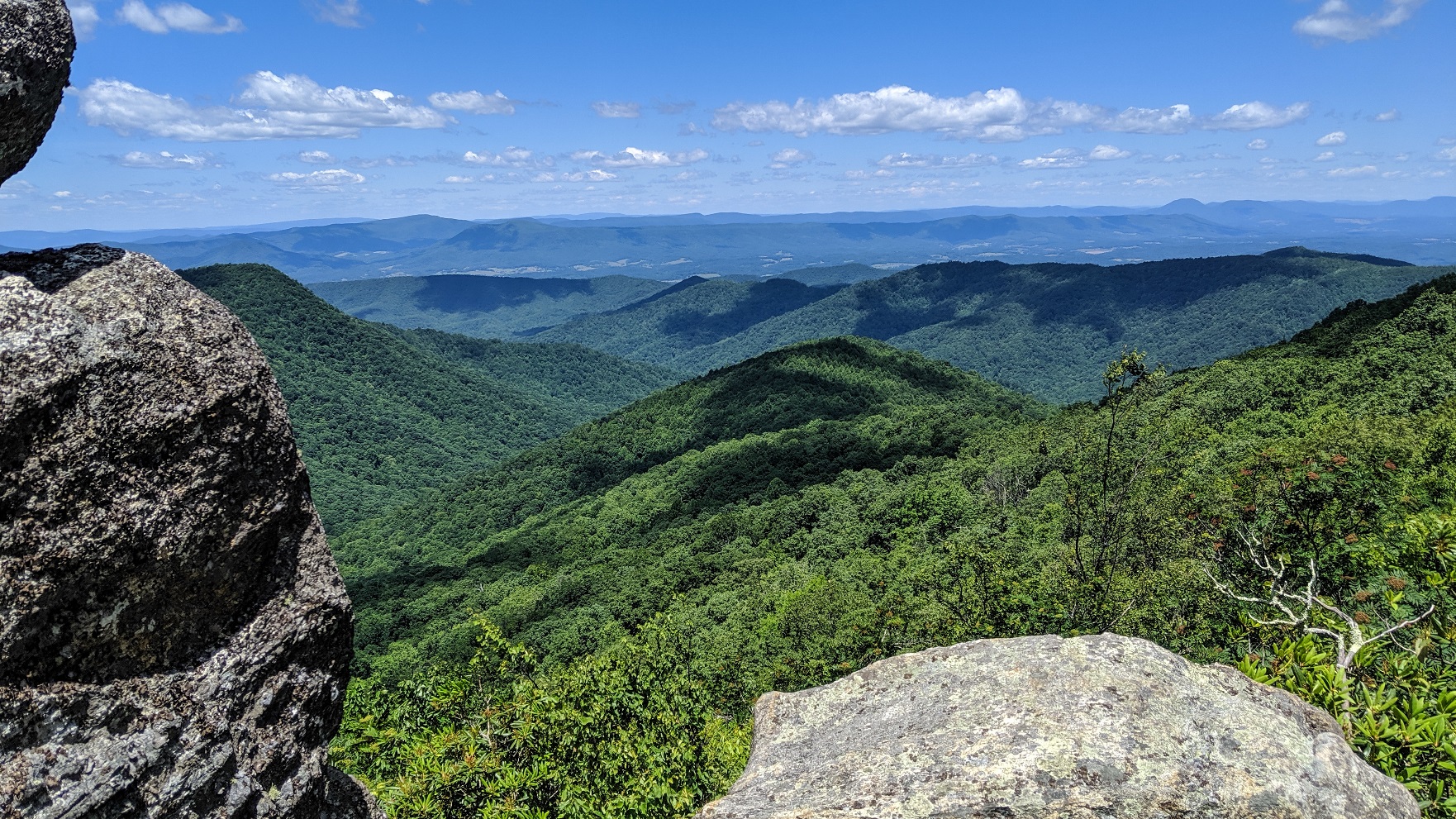
At 6 miles I reached the Black Rock Overlook, which had nice views to the west.


Shortly after the overlook there was a small stream with a sketchy looking footbridge.

Somewhere after this I entered the Thunder Ridge Wilderness at 2,428 acres the smallest of Virginia’s wildernesses. The birding almost immediately became spectacular. Warblers were everywhere in the canopy above me. My phone camera isn’t suited to zoom photography, but I did manage to get one half decent shot of a cool bird.

As the trail began the second big climb of the day it crossed over a couple of knobs with stunted trees, what my wife likes to call “fairy forests.”

At 9 miles I finally crested the open summit of Apple Orchard Mountain, home of a strange weather radar station. Thee were nice views to the north.


I had 4 bars of Verizon here, so I took a short break to check in with my wife and kids before hiking on.
As I re-entered the forest, I started to see a lot of wild columbine.

I then passed under “The Guillotine,” which I inexplicably forgot to take a picture of. Here’s what it looked like:


A short distance later the AT skirted a large meadow fringed by spruce trees.

At 10 miles the AT crossed our old friend the Blue Ridge Parkway and began a gentle descent. Not long after crossing the road there was a side trail down to a pooling spring. I decided to camel up here with 5 liters, which proved to be a great call since I never found the water source at the subsequent shelter.
This last bit of trail was rimmed by Beardtongue flowers (Penstemon sp.).

I finally reached Thunder Hill Shelter at around 4:30. I was to have the unusual experience of having it to myself for the night despite being in the midst of a thru-hiker bubble.


I cooked an early dinner of creamy pasta shells and then sat for a couple of hours in the shelter listening to and watching the many birds in the area. I beautiful male Scarlet Tanager visited, and then aBarred Owl. Meanwhile, a Veery and Eastern Wood Pewee were busy dueling each other vocally. The call of the Veery sounds like the noise you hear in Pac-Man when you die. I also saw an American Redstart and a Black-and-white Warbler. AND a large doe wandered right into the middle of camp.
As dusk came it got really windy. There was a bright moon too, so I kept seeing lots of moving shadows, It was kinda creepy, especially with all of the continuing animal noises. It was easy to imagine a bear lurking out there. But I was finally able to fall asleep. Bourbon might’ve helped. Day 7: 10.6 miles.
I hit the trail before 8 AM the next morning. My original schedule had me hiking about 11 miles to a campsite past Marble Spring, but I was already considering the possibility of going a couple of miles further to the shelter, or possibly (gasp) even a couple more miles to just go ahead and complete this hike. Knowing that Glasgow had a highly-regarded Italian restaurant was certainly providing some inspiration. I figured hitting the trail early would at least give me options.
About a mile and half into the morning I reached the Thunder Ridge Overlook. I took the short side trail to the parking area and took advantage of their trash can. My pack weight even with water was now down in the 13-14 lb. range, which felt like nothing.

The views from the overlook were especially good.


A tourist had left behind a shirt. Reading it had me motivated to get home quicker.


A large sign announced that I was now in the James River Face Wilderness. Established in 1975, this 8,900 acre wilderness is the oldest in Virginia.


Almost the entire day was spent losing elevation. I passed Buffet and Lifesaver in Petite’s Gap, and then tackled an annoying 700 ft. climb to the forested summit of Highcock Knob (lots of Gray’s lilies along the way). Because AT.
The trail then descended to an open grassy area in the woods- Marble Spring campsite. It wasn’t even noon, and I’d already knocked out 7 miles, so I took a break to go down to the spring and fill up.


When I returned from getting water I met 8 young college kids from Liberty University out on a day hike. They were looking for the Devil’s Marble Yard, which was actually 5 miles away, and didn’t seem to know exactly where they were or exactly how to get out of the woods. I went over the trail map with them using Guthook, and also guided them to the spring before I left (they were out of water). They were nice kids, and as far as I know they got out ok.

The trail then flattened out and followed the dry side of a ridge for several miles before descending gently and finally reaching Matt’s Creek Shelter, where I stopped for a quick snack break.

Wild Violet was just leaving as I arrived, and she gave me final thanks for her cheeseburger and milkshake. After a short break, I checked the time- 3:45. I’d come 13 odd miles in 8 hours, and it looked like I could hike the remaining 2.2 miles in plenty of time to get to the restaurant by dinner time.
The trail followed Matt’s Creek for a little ways then veered off and descended down towards the James River, which it reached about a mile later.

The trail stayed in the woods parallel to the river for about a mile before arriving at the James River footbridge. At around 1,000 feet, it is the longest footbridge on the AT.

There were lots of tubers and kayakers floating by. One tried to toss me a beer, but the distance was too great. It’s the thought that counts though.


The bridge led to a small parking lot on the other side, where I was quickly able to get a hitch to Glasgow from a nice couple. I then returned to Stanimal’s and paid Donna my parking fee, said hi to Polar Bear and PJ who were lounging in the carport, and headed to Scotto’s.
I was greeted by a nice waitress, and I asked her if they minded serving a smelly hiker. She replied that they loved hikers so much that they had a dedicated room just for them. And sure enough, there were already 3 hikers in it.
I ordered a MASSIVE amount of food- fried shrooms, large salad, cheesy garlic bread, and chicken parmesan with a side of spaghetti. I. ATE. IT. ALL. There is no shame in my food game.

Somehow all that food didn’t put me into a torpor. I managed to drive all the way to Rogersville TN before stopping to get a hotel room, and made it back home by noon the next day.
It was a great end to a hike, one that despite a bit of yellow-blazing was one that I had to consider a success. I survived nasty rain, my first blister, lots of significant climbs and some equipment failures, yet still managed to finish ahead of schedule. Maybe, just maybe, I’m getting tough enough to be considered a “real” hiker. I’m certainly looking forward all the more to my future hikes. Day 8: 15.0 miles. TRIP TOTAL: 81.5 miles.
Recent Comments