Backcountry adventure and cuisine for aspiring hiker trash
Guide To Hiking The Lakeshore Trail In Pictured Rocks
Some advice on logistics from a fellow backpacker who bumbled his way through it
When I was planning my recent hike of the Lakeshore Trail through Pictured Rocks National Lakeshore, I didn’t find a lot about the logistics on the internet. Fortunately, I did find several helpful blog posts that pointed me in the right direction. Because I enjoyed this trip so much, I’m going to attempt to help those who will come after me.
My backpacking style is a little different from most. I’m usually driving at least one day away from my home to enjoy up to 9 days on the trail and in trail towns. I’m not necessarily concerned with crushing miles, and it’s important to me to experience the towns too.
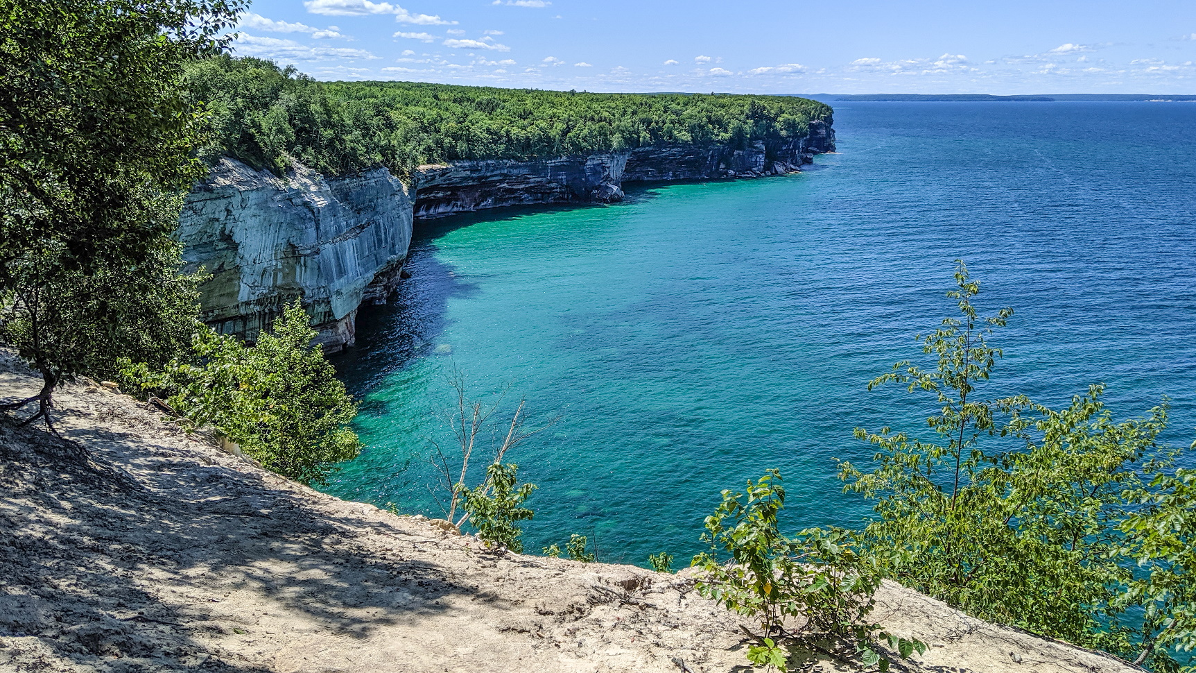
Now, this is a pretty easy hike. The trail is 42 miles long, but the FKT is just under SIX hours, so obviously it’s pretty flat and easy trail. The average hiker can easily do this trip over 3 days, making it quite suitable for a quick 4 day weekend type of trip. My advice to you though is to dial back the miles. There’s a lot fine things to divert you from the trail, especially the beaches. Spend some time on them. Heck, take a swim. Sleep in the sun. RELAX.
I also encourage you to spend some time in the bookend trail communities of Munising and Grand Marais. The population of Munising is about 2,300 and that of Grand Marais is a mere 322 if Wikipedia can be trusted. Both towns are four-season tourism destinations, with hiking, fishing and water sports during the summer and snowmobiling, ice fishing and cross-country skiing during the winter. I hike on their trails, and I therefore feel a bit of an obligation to kick some coin into the local economy. I want them to LOVE backpackers.

just before you hit the main intersection with H58

I think it’s easier to stage from Munising. There are abundant lodging options and places to eat, and the Altran shuttle works better from here. The lodging is expensive. I stayed at the Sunset Motel on the Bay at $170/night. It’s right on the lake and is less than a mile from the Munising FALLS Visitor Center, which is the first stop on the Altran shuttle rounds. But there’s plenty of cheaper options. You can even stay at the Munising Tourist Park Campground for a mere $25 and have access to showers. You can find a host of other options using Google Earth.
While you are in town, you should check out at least one or two of the following eateries: Taco Primo, The Fish Basket, Pictured Rocks Pizza, Bay Furnace Bagels and Eh! Burger. You should also try a pastie somewhere (supposedly the best ones in town are at Muldoon’s).
If you hike east to west instead, or if you feel like driving an hour from Munising after you finish, the Dune Saloon/Lake Superior Brewery is a must in Grand Marais.
Before you drive up here, you need to reserve your campsites, because you’re not allowed to stealth camp. Check out the Backcountry Camping page for Pictured Rocks. Specifically, check out the Backcountry Planner, which has information on campsites. The overview map of campsites will guide you in planning your itinerary. Pay attention to the occasional campsite that doesn’t have a water source or allow campfires. Pay special attention to privy status, I think there’s a couple that don’t have one. I can personally recommend Au Sable East, Sevenmile, Coves, Chapel Beach and Mosquito River for camping.

I heard that Trappers Lake was meh, Pine Bluff definitely looked meh to me, Cliffs is nothing special and doesn’t have a water source, Masse Homestead is meh and doesn’t have water, and Potato Patch doesn’t have water. You will pass through drive-in campgrounds at Hurricane River and Twelvemile that have full facilities if you go off trail to find them. And Miner’s Beach parking lot has a porta potti and garbage cans. So does the Visitor Center at Miner’s Castle.
After you plan out your itinerary you need to go to Recreation.gov to reserve your permits. Sign in or register, then type “Pictured Rocks” into the search bar. Multiple options will pop up right below the search bar, click on “Pictured Rocks National Lakeshore,” which is the topmost option as of today. You will then come to a page with a Google map view on the right and some options on the left; of these select “Pictured Rocks National Lakeshore Backcountry Camping Permit.” Towards the upper right of the next page, click on the blue bar that says “Build Itinerary.” On the next page, first enter your group size at the upper left. Then start scrolling through the dates on the calendar. The prime dates are not likely to be available within a few days of a trip, so plan ahead. As of today (August 23rd) there’s nothing available until the first week of September.
Campgrounds are located at 2-5 mile intervals along the trail, so it’s pretty easy to craft a trip to suit your needs.
CAMPSITES

The campsites are typically a maze of trails that connect anywhere from 5-10 or so individual campsites. Almost all of the campsites are really close to the main trail. MOST campsites have a privy, which could have 0, 2 or 4 walls, so be prepared to shed your modesty. MOST campsites have water sources, most often Lake Superior. Most campsites also have 1 or 2 group fire rings. ALL campsites have bear-proof food storage, so leave your bear bags, Ursacks and bear cans at home. Just bring a suitable food bag.

BUGS
Biting insects of the north woods are legendary. In late spring to early summer, ticks, black flies and mosquitoes can literally drive you mad. By late July to early August, most of this has dissipated, although stable flies can be a nuisance on days with a southerly wind. Bottom line- pre-treat your clothing with Permethrin, and have some Picaridin or DEET on your person. I would also recommend wearing thin synthetic long sleeve shirts (which I did) and pants (which I didn’t).
CLOTHING
Obviously whatever is seasonally appropriate. If you go in August like I did, the average high/low temps are low 70’s and low 50’s. I didn’t bring a puffy, but did have an UL fleece set plus my rain jacket if it got chilly, which it didn’t.
I strongly recommend gaiters. You won’t regret having a pair of Dirty Girls with you. There is a lot of hiking through loose sand, and sand in your shoes kinda blows.
Although I saw a lot of people in boots, there’s no need. Trail runners are what you want.
I brought sunglasses, but they weren’t really that necessary except when I was on the beach.
GEAR
You can view my LighterPack for this trip HERE.
This is an easy hike to try to do ultralight. You don’t need much carried clothing, food storage is a breeze, and you can get away with a summer pad and sleeping bag or quilt. Also, water sources are frequent- I never carried more than 1.5L at a time, and that was overkill to be honest.
If there’s ever a trip where packing a bathing suit and having flip flops as your luxury items made sense, it’s this one. Because BEACHES.


THE TRAIL ITSELF

I found the trail very easy to follow except through Twelvemile Campground, where if you stick to trails near the shoreline you’ll end up fine. The trail isn’t blazed, though, and only occasionally do you see a post with a North Country Trail marker on it like above.
Additional signage was generally adequate, particularly on the eastern portion of the trail.

There was additional signage for points of interest such as Log Slide and Miner’s Castle.
The trail is mostly firm soil when it’s in the woods, sometimes lightly mixed with sand. But sometimes the trail practically wallows through loose sand near the shoreline, such as at Twelvemile and Miner’s Beach. But hey, variety is the spice of life. There are also a few modest climbs on some rooty trail, but rocks were minimal. The last few miles at the western end of the trail had muddy spots and are probably a PITA during rain or a wet season, so be forewarned.
SHUTTLE
The ALTRAN (Alger County Transit) shuttle service is crucial. Their backpacker shuttle service was amazing. They went out of their way to help me.
You need to visit their website HERE to make your reservations, which you should do at least a few days before your trip. It’s $25 well spent. Probably the top option for backpackers is to get picked up at 8AM at the Munising FALLS Visitor Center (not the Munising Visitor Center), which will get you to Grand Sable to start your hike at roughly 9.15.

Recent Comments